Tuesday, May 29, 2012

Sea Otters

Sea Otters

In 1741, when Vitus Bering stumbled onto Alaska at the top of the panhandle, sea otters, whales, fur seals, salmon, etc were abundant. [For a timeline, many of the crew were born in the early 1700's; Benjamin Franklin was born in 1707; Montcalm in 1712; James Cook in 1728; James Wolfe in 1729; Haydn in 1732.] On their return voyage to Siberia, Bering and his crew were forced to overwinter on an island between the Aleutians and Siberia. Bering died and their ship was wrecked. They survived by eating these animals, which were as fearless and unused to humans as their counterparts in the Galapagos - there were flightless cormorants in both areas. The survivors built a crude boat from the salvaged wreckage and made it back to Russia in the spring. Word got out about the wealth of fur bearing animals and especially the sea otter with its luxurious fur. After only 40 years, hunters had practically wiped out the sea otter population in Alaska and BC. Within the last 50 years their numbers have been expanding through reintroduction in their original habitat and protection from hunting.

We love sea otters. They are very shy. So when they appear, it is a special treat. They are a close cousin of the river otter and are the only sea mammal that does not have a thick layer of fat for insulation. They retain their warmth with a thick coat (800 million hairs!) which they clean especially after eating but almost any other time when they are not playing or sleeping. Their hair also traps air to aid insulation but it also acts like a PFD (personal flotation device). They shed hair continuously; a molt would lead to hypothermia. One source says that a coat made entirely of sea otter pelts would be too heavy to wear.

Sea otters spend their life at sea (Bering's naturalist Georg Steller did see them inland on an island). They even give birth and sleep on kelp beds. They wrap themselves in kelp to steady themselves during storms.


Sea Otter with Pup

They are not deep divers and have to eat continually, about 30% of their body weight per day; therefore, they are non-migratory, staying in their home territory until population pressures encourage the younger ones to less inhabited bays. Their favorite food is sea urchin but they will eat octopus, crabs, clams, mussels, snails, finfish etc. When they catch food, they tuck it into a loose fold in their armpits (like shopping bags!) In their leg "shopping bag", they store stones to pry off abalone or break the shells of shellfish. With their hand-like forepaws, they catch fish and turn over rocks, sometimes releasing food for cormorants! Recent evidence shows that they can tell if shellfish has PSP (red tide poisoning).

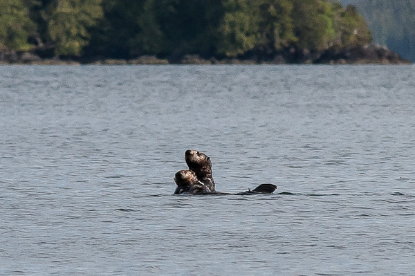
They can give birth at any time of the year, always a single pup. Right now, we see many mothers with their young. The moms are very attentive, bringing up food, which they both eat on their backs; playing splashing games; diving and surfacing in tandem. And when mom sees something suspicious (like us!), she puts her arm around the pup and they both push their heads up high to get a better view (or smell?).

They are most important to the fishing industry because of their appetite for sea urchins, which mow down kelp forests that protect the ocean floor from erosion and give shelter to immature fish. However, when we talked to some fisherman in Hydaburg, they were not happy with the reintroduction of the sea otters, which they blame for destroying their clam beds. Maybe they will notice an increase in the number of fish they catch. Maybe not, since there is a lot of new logging here, which they say is destroying their salmon streams.

Hydaburg

Sunday May27 - Tuesday May 29, 2012

Hydaburg Harbor
  After the Barrier Islands we anchored in Mabel Cove on POW Island. Uneventful. No crabs.

Left Mabel Cove and headed to Hydaburg on Sunday, as a storm was approaching. On the way, we fished briefly near a rocky headland until we had two nice rock cods. The entryway to Hydaburg Harbor is littered with rocks. I asked Urs, "Is that buoy red?" Then the depth alarm went off. Hard turn to the left. Red buoys warn of an obstruction on the right; sailors say, "Red [buoy on the right] right [when] returning [to harbor or going north or west].


Joe and Younger Carvers

Hydaburg Harbor is no longer maintained by the government and the local population hasn't taken over yet. The breakwater is suffering. The outer fingers don't have electricity. One whole dock and pilings are tipped at 30 degrees. There isn't even a wharfinger to assign a berth but there was lots of space. As we tried to dock, a man walked toward us. I asked if he could take our line - we were a long way from the finger and the wind and current were not helping. He pointed out that, though our finger looks new, it has no electricity and we could use his outlet. He also pointed to one of the neighboring fingers and said there was a sunken boat! Nice.


Joe's Totem at Boys and Girls Club

Hydaburg is 100 years old. There will be a celebration in November this year. In the 1800's (or before?), some Haida from Haida Gwaii (Queen Charlottes) crossed Dixon Entrance (which they had considered the end of the world) and settled in the islands around Prince of Wales. In 1911, four small villages decided to move together in a larger village so that the children would have a better school (and probably that they could fish cooperatively and have a grocery store, etc).


Joe's Totem At Boys & Girls Club

Our friend from the dock had told us to go to the carving shed. So we walked through the village, looking at the totem poles in front of the houses. Carvers welcomed us warmly to their shed. They had three old totem poles, each lying parallel to an unfinished new pole. Master carver Joe (also called David) gave us the introduction to his great-grandfather's pole. He described it as a transformation pole, with a lake monster, which I'd never seen before. He has carved several other poles for the village, one very nice one at the Boys and Girls Club - carving of children and guardian animals?

The younger carvers were very friendly, asking about our travels, and telling us about their other jobs, like responsibility for the engines on a research boat.

Later two young Haidas walked over to our dock for a friendly chat. They had seen us cruising past while they were out fishing. They were happy to have caught a good sized king salmon (Chinook) and then brought us a few pieces.


Naval Officer

Another master carver, James Bell, is the cousin of the late Bill Reid [a very important artist in reviving Haida art]; they worked together on several poles in Masset and Skidegate. He walked with us around the other two poles. One was obviously a story about European contact: an American-style eagle, a naval officer with gray beard, and one source says that the watchmen at the top are naked, a sign of their offense at the interference of the Europeans.


American Eagle

The three poles are replicas of replicas of the poles brought to Hydaburg from the parent islands. They are hoping to raise the new poles at the end of July. They will join the dozen or so poles outside the school. They are also hoping to build a long house and have dozens of cedar trees waiting to be carved.


Trying to follow the instructions on the sign in the harbor, we reported to the Town Office to say that we are tied up at their dock. No one seemed concerned.

Saw a new way of walking a dog: get in the car and follow the dog from one end of the town to the other 5 or 6 times! I'm not kidding.

The storm intensified Tuesday and the boat is heeling over at the dock with the gusts and is forcing us to keep our drawers locked to prevent them from sliding open.

Saturday, May 26, 2012

Around the South End of Prince Of Wales

Wednesday May 22 to Saturday May 25

After leaving Ketchikan, we pulled up to the fuel dock for diesel and oil. Two US coast guard boats pulled up. I was startled to see a machine gun mounted on the bow of both boats.


Porpoises and whales popped up as we headed out Clarence Strait toward Prince of Wales Island. Anchored overnight in Gardner Bay before rounding Cape Chacon. Then anchored in Nichols Bay - Nichols was a New Yorker who surveyed the area in 1880's. The weather was perfect: blue sky and practically no wind. Dixon Entrance was practically flat, very unusual as there is no land until Japan. On Friday morning, the wind was howling 30 knots in Nelson Bay. However, the weather stations were reporting much less wind and 2-foot swells. So we headed out to Dixon Entrance again and it was indeed pretty flat, though the chop made it difficult to see the logs -- hitting one sounds awful. Stopped in the Barrier Islands in an anchorage nicknamed Charlie's Cove. We're back in protected waters and shorter hops -- I call this the Outside Inside Passage (Dad would have loved that!). Today, we saw another boat (fishermen) for the first time in four days.

Judy on Dinghy

First Black Bear of the Season


We put the dinghy down and went exploring Thursday and Friday. Saw our first black bear of this trip, who was vigorously digging for food (a carcass?) under a pile of drift wood; very healthy looking for this time of year. We also saw several groups of sea otters. They are very curious - several approached and then stuck their heads up to get a better look (or smell?). The moms are very protective of their pups. When they stick their heads up, they have an arm around the pup. When they dive, the pup rides on her back or is clutched to her chest. They love to play. Cannot get enough of them! 
Urs with Flotsam


We have a saying that the most reliable force in the universe is gravity. It never fails, especially over water. Unfortunately (very), it worked again. While Urs was off gathering floats on a beach, I was fiddling with the dinghy anchor and my iPod fell into the water. Why couldn't it have defied gravity just this once? I enjoyed it so much.

Back to a better report. The weather has been fantastic, sunny since leaving Ketchikan, but still two- or three-sweater temperature.


Tuesday, May 22, 2012

Ketchikan


Saturday May 19 – Tuesday May 22, 2012

Saturday, the motor was running at 7 AM and we headed out into Dixon Entrance, which separates BC from Alaska. There was a 2-foot swell.  Mostly, our course was at a 45-degree angle to the waves; however, when it was parallel, Raven Song rolled along with the swells, to the displeasure of the crew.  We entered Ketchikan after 8 hours in sunshine and strong wind toward the end of the day.
Raven Song among fish boats
Getting into our slip was a bit of a problem.   We discovered that there was already a boat in the slip the harbour master had assigned to us.    The strong wind made it hard to maneuver Raven Song, but Urs managed to turn her around in the narrow passage way.  We tied up at the second assigned slip; the tide and wind moved us away from the dock.  So Urs had to back out and try again.  Then we discovered that the slip had no electricity, so had to back out and go into another slip among fishing boats that dwarf Raven Song!   A very nice customs officer cleared us easily.
Cruise Ships at Ketchikan (tallest mast is on left is Raven Song
The next few days were filled with chores:  made three trips to the grocery store, bought a cell local phone (there is no cooperation between Canadian and US phone companies), got a fishing license (don’t ask how much it cost), etc.  We treated ourselves to a halibut meal in a restaurant on a nearby hill.

And we went sightseeing.  Ketchikan seems to survive on fishing and tourism.  The importance of fishing is clear from the abundance of enormous, well-maintained boats.  The importance of tourism is clear when the cruise ships arrive, up to three a day.  Passengers poured out onto what had been quiet streets.  Officials suddenly appeared with stop signs making sure pedestrians didn’t get run over or cause traffic jams.   The shops that had been closed were suddenly inviting everyone in for a free gift or a sample of reindeer sausage or salmon.  Tour operators popped up and started hawking their itineraries.  I heard one man say that 4800 passengers visited one totem park this morning!!  We visited two different totem park this morning and could barely find a couple of seconds to take a photo.


There are three totem parks near Ketchikan.  In the 1930’s, people started to recognize the art in the totem carvings and paintings.   Over the next two decades, they moved them to museums and started carving replicas.  Three native groups are represented:  Haida,  Tlingit, Tsimshian.
Tomorrow, we plan to untie our lines, fill up diesel, and head to Prince of Wales Island, known locally as POW!!

Big House at Saxman Totem Park
Totem at Saxman Totem Park


Friday, May 18, 2012

Last day in BC for a while

Thursday May 17 - Friday May 18

On Thursday, we left Grenville Channel and headed for Prince Rupert. When we reached open water, we had winds of 35 knots, on the nose, of course! Much lighter wind had been reported in the morning. Sea was an unpleasant chop until we rounded the corner to Prince Rupert Harbour. We could not find a place to tie up, so we headed for a nice anchorage. At the mouth of the anchorage, there was a minefield of black floats -- very hard to see in the chop. Despite a bow watch, we nicked one of the floats. I had choice words for the floats' owners.

Prince Rupert of the Rhine and Duke of Bavaria (1619-82)was created Duke of Cumberland by his uncle, King Charles I. He commanded the Royalist cavalry in the English Civil War at the age of 23. When Cromwell won the war and Charles lost his head, Rupert became a buccaneer in the Caribbean. After the restoration of Charles II, Rupert returned to England and became a commander of the Royal Navy. Later, he was governor of the Hudson's Bay Company.

Chart around Kitkatla
Today, there was no wind and the floats were much easier to see. We slalommed our way through the rocks and shallows around Kitkatla, one of the oldest continuously inhabited communities along the BC coast. We are now anchored on the north end of Dundas Island. There is a clearing of rocks on the shore. This is a sign that there was a native canoe landing place here.

Tomorrow, we will get up early to catch the tide to Alaska. The winds are predicted to be favorable but will increase in strength on Sunday. So we may decide to go all the way to Ketchikan, rather than stopping at Foggy Bay.

So we made it to the north end of BC in 14 days of travel. It would have been slower if we hadn't had benign weather and pushing tides. We still have enough fuel to get to Glacier Bay!

Wednesday, May 16, 2012

Grenville Channel

Grenville Channel
Today, we motored up Grenville Channel. The channel is so straight that we maintained almost the same course for 8 hours (41 nm) -- very unusual. The channel is very narrow; we keep a constant watch for cruise ships.

This morning was gorgeous: clear air, deep blue sky peppered with white clouds, deep green slopes peppered with patches of shadows from the clouds, white-capped mountains in the distance. It turned very cold and rainy, with a 30-35 knot headwind by afternoon. No swell, just a chop but slower going. This would be the perfect wind to be sailing down the channel under a poled out head sail.

Yesterday, I included the reason Rescue Cove got its name. I will include similar notes this year. My reference is Andrew Scott's Encyclopedia of Raincoast Place Names.

For context, Grenville Channel goes between the BC mainland and Pitt Island and is part of the Inside Passage to Alaska. "Lord Wm Grenville was a noted British Liberal statesman. ... His wife, Anne Pitt, had a brother serving as midshipman on HMS Discovery, Vancouver's vessel. This was the notorious Thomas Pitt, later Lord Camelford, who had to be discharged in Hawaii in 1794 for insubordinate conduct. Vancouver had Pitt flogged. ...Back in London, Pitt challenged Vancouver to a duel. ... Pitt's bad-mouthing helped gain Vancouver a reputation as a despot and bully, [eclipsing] his remarkable achievements. Pitt was acquitted of other violent acts, including outright murder, because of his wealth and exalted connections. Pitt was killed in a duel at the age of 29."

We are anchored behind a small island in front of Kumealon Inlet, a small side inlet east of Grenville Channel. In 2006, we took the dinghy into the beautiful nearby lagoon. It was so beautiful, we stayed too long; the entrance had become white water rapids as the tide dropped on the outside, exposing a 3-foot drop over rocks. Urs quickly raised the motor as we accelerated towards a patch of white water. Judy thought of the possibility of a poor, orphaned Magpie as we glided down the waterfall.

Tuesday, May 15, 2012

Steady Progress Northward

Sunday May 13 - Tues May 15

Reflection at Rescue Cove
We're making steady progress northward and the weather has been warm and sunny. Unfortunately, we've had wind on the nose for the last two days; today it was up to 25 knots dead ahead.

Chart of Jackson Narrows
Sunday, we left Shearwater, headed out Seaforth Channel and then, to avoid the swells of Milbanke Sound, we slalomed between the rocks in the narrow Reid Passage behind Cecilia Island. Finally, we anchored at Rescue Cove, at the NE corner of Susan Island just before Jackson Narrows. Was sure that there had to be a dramatic tale that gave the cove its name. It turns out that a dog fell off a fishing boat and was rescued in the cove! It should have been a clue that the entrance to Jackson Passage is Spaniel Point! Jackson Narrows has a very narrow and shallow, squeeze-through passage between rocks, but the narrow part is very short. Nevertheless, we do have a good friend who ran aground here. Definitely not a pleasant experience.
Panorama of Jackson Passage
Raven Song in Jackson Passage

Monday was a long day, 45 nm (maybe 80 km). North through Tolmie Channel and Graham Reach, where we saw two orcas (probably transients) feeding. We headed into Khutze Inlet, a place where we'd wanted to anchor years ago but couldn't find space. The anchorage is a small 90-foot deep shelf in front of the mud flats of the expansive estuary; one boat was already there and two boats were arriving behind us! After a careful search, we found the shelf and put the anchor down. Urs lowered the dinghy, we put out the crab trap using the prawn heads for bait and took the dinghy up the river to look for grizzly bears. We did not see any, but observed several young seals and birds about to nest.

Khutz Inlet
What is particularly nice this year, is all the snow-capped mountains. In Khutze at our anchorage we were sitting in the bottom of a tight bowl of high mountains and along a spectacular cascading waterfall, the snow came down to the water in a ca 6-meter dump off a snow chute. We were unable to make e-mail contact that night, probably due to the steep mountain bowl we were in.

Tuesday morning, we pulled up a trap full of crabs; kept 2 huge males -- more crab for dinner! We went along Princess Royal Island, where we had seen Spirit bears in past years. Princess Royal is so steep that it hasn't been settled, so it's a good place for the bears to survive. The scenery was spectacular: sunny day and lots of snow-capped mountains. We paused a moment to remember The Queen of the North, that sank here in 2006, before anchoring just south of Hartley Bay.


It looks like the weather will be good to cross Dixon Entrance into Alaska on Saturday: light SE winds. We will be in Prince Rupert on Thursday.

Saturday, May 12, 2012

Prawns for lunch! and Dungeness Crabs for Dinner!

We pulled up two huge Dungeness crabs and 70 prawns, some large, some small!!  That pays for our fishing license! 

We stopped at Bella Bella to fill up water and groceries.  Then anchored in front of Shearwater Marina, just east of Bella Bella.  Neither grocery store had any milk or orange juice!  Oh, well, it's back to frozen oj and powdered milk.

Weather is warm and sunny -- no sweater!  But a storm is coming in a couple of days.

Haven't figured how to get blogger to accept pictures from an email.  So they will have to wait until we get to an internet cafe.

Codville Lagoon

Sandy Beaches at Fury Cove

Swiss Choir at Heriot Bay Inn

Friday, May 11, 2012

Prawns for dinner tomorrow?

May 8 -11, 2012

Tuesday, we left Cutter Cove about 9 AM and followed the protected waters within the Broughton Archipelago through Knight Inlet to avoid strong winds in Johnstone Strait. Then headed into Queen Charlotte Strait and half of the way out where we anchored in Blunden Harbour, a well-protected anchorage in front of an abandoned native village site. All that is left now of the once thriving village are moss covered beams from houses lying in the grass above the beach. No other boats in the anchorage.

Wednesday, we considered rounding Cape Caution, one of the two major stretches of open water that we need to cross this summer. The marine weather reporting stations along the way were reporting up to 6 meter waves, the result of the previous day's storm. We decided to get a little closer to Cape Caution and anchor in Allison Harbour. Unfortunately, some of the route was not entirely protected from the high waves. Everything that we had planned to put away the next day, fell onto the floor: all Magpie's toys, books, soap, a candle with its plate; the plate was the only casualty! Magpie was not impressed and regurgitated her breakfast after a long mournful cry. She calmed down in my lap. The seas finally smoothed out as we got behind the reefs leading to Allison Harbour.

Thursday, marine weather reporting stations reported swells to be 2-3 meters. So we stowed everything as we should have yesterday! and headed out. Another slalom around the reefs and rocks. Two meter waves didn't sound like much, but after 4 hours, it got old. Magpie was not happy but resigned to the life of her family. There are no inlets in which to take refuge for about 4 - 5 hours around Cape Caution. Maybe that is the reason that we saw so many sea otters (ca 18) lazing on their backs in the swells - not many people there and lots of safe places for them to hide. We still haven't seen any whales. We crossed Smith Sound and Rivers Inlet and followed Fitz Hugh Sound and turned into Fury Cove, one of our favorite anchorages with sandy beaches and a view of the mountains.

Friday, we motored up Fitz Hugh Sound with only a light wind on the nose but nice sun. Saw our first hump back whale!! It looked like a log in front of us. As I debated whether to avoid it on the left or right, it made a shallow dive, then surfaced again a couple of times, until he disappeared behind us. Very exciting! We anchored in Codville Lagoon after putting out two prawn traps. We've caught prawns here several times before but this time, we saw a commercial prawner and lots of floats over his traps. Put out a crab trap, too. And there is a curious, probably juvenile seal that keeps checking us out.

Monday, May 7, 2012

Back on the Road Again

Wednesday May 2 - Monday 7, 2012

After the wind died down, we left Spruce Harbour Wednesday morning and promptly ran into a hail storm. However, we saw a harbour porpoise at the end of English Bay and decided that was a good omen. We went quickly up the coast, arriving Thursday night at Quadra Island where the Swiss choir was meeting.

We came to the dock on Friday morning. As I was about to walk up the ramp to check in, I heard, "Hello Judy!" It was Karin - two carloads of singers had already arrived. We spent most of the day talking and fixing things and giving boat tours.

On Saturday, Rolf and Heather Kellerhals invited the choir to their farm. Rolf is originally from Bern. They were at the Swiss Choir Singing Festival in Vancouver last June and met Marie-Louise, our choir president. That was where the idea of an excursion to Quadra was hatched. The Kellerhals farm is one of the original quarter sections (1/4 x 1/4 mile) given to the European settlers. When we arrived, a half dozen cattle greeted us as if they had never seen so many people at one time! Rolf and Heather showed us their orchards and gardens. Then we went to the beach to harvest clams and oysters. In the evening, we sang in the Heriot Bay Inn to a sold-out crowd.
Sunday morning we sang at the native church on south Quadra. Dubravko, our choir director, played the organ. Reverend Mimi and her helpers gave us lunch.

In the afternoon, untied our lines to catch the slack at Surge Narrows (it runs up to 11 knots) just north of Heriot Bay and then anchored around the corner in the Octopus Islands.

Monday morning we got up at 5 AM to catch the next narrows in Okisollo Channel at slack and headed up Johnstone Strait. A pod of Dall's porpoise were feeding in the eddies. We had up to 6 knots (10 km / hr) current with us, so our speed over ground got up to 12 knots. We had lunch at a temporary anchorage. Magpie was grateful for the respite. We went through the next narrows, Chatham Channel, at 6 PM at slack water. Anchored in Cutter Cove; it's a good crabbing spot but we're too tired.

So we've made pretty good progress on our way to Alaska and managed to see friends along the way!

Tuesday, May 1, 2012

Alaska Bound

We've packed up everything -- provisions for weeks and all our winter
clutter. We plan to untie the lines early Wed May 2, 2012. Weather
forecast is for southeasterlies--- that's what we like going north.
Hope to get as far as Pender Harbour the first day and maybe The
Copelands on Thursday.

Judy will sing with the Vancouver Swiss Choir on Quadra Island May
5-6.  She is looking forward to that and will miss the choir
companionship over the summer.

Judy and Urs will head north on Monday May 7, with the aim of being in
Alaska by June 1.

Stay tuned.