Thursday, August 9, 2012

Glaciers in Tracy Arm

Tuesday August 7 - Friday August 10
We're heading south now and will be in Petersburg on Friday, if all goes as planned.

House-Sized Bergy Bit
Wednesday was a tourist day. We spent the day going up and down Tracy Arm to see North and South Sawyer Glaciers. It was 10.5 hours of motoring but worth it. Some of the smaller bergy bits were difficult to see in the pouring rain that bracketed our trip. We marveled at the various shapes of the larger, deep sky blue ice bergs. Are ice bergs, like snowflakes, unique in shape?

The high rock walls and domes reminded us of Yosemite: very steep, lots of scratches from the rocks in the moving glacier. The horizontal scratches were inhabited by various stages of vegetation, from grasses to bushes to small trees.

Three Ships Meet in Tracy Arm
Large and small waterfalls cascaded down the steep walls. With all the fresh water going into Tracy Arm, the current was always toward the mouth despite the tide. On the way out, we were moving up to 10 knots! I tasted the brackish water at the glacier.

Both glaciers have receded since the charts were made several decades ago. At North Sawyer Glacier the GPS information showed that the glacier had receded by about one nautical mile. Both are tidewater glaciers, which means that they can calve into the water causing large waves. In North Sawyer, we stayed back a half mile. There was an ice shelf in front of South Sawyer. When we got close to the ice shelf, we saw that it was covered with seals and their mostly-grown pups. The glacier faces were an intense blue. The sun also came out at both glaciers. Very nice.

Vegetation in Horizontal Bands
Waterfalls
U-Shaped Side Valley
Chrystal Bergy Bit
Sea Gulls Resting on Large Bergy Bit
North Sawyer Glacier
Arrow is Raven Song's Location with Depth of 454 ft;
 Glacier Face is Now 1 Mile Farther Northa than on Chart
North Sawyer Glacier
Approaching South Sawyer Glacier
South Sawyer Glacier
Seals on Ice Floes in Front of South Sawyer Glacier
South Sawyer Glacier
Crushed Ice is Hard to See
Disney Wonder Approaching South Sawyer Glacier
South Sawyer Glacier
Disney Wonder in Bay of South Sawyer Glacier


Wednesday, August 8, 2012

Pack Creek Bear-Viewing Area

Sunday August 5 to Monday August 6

The introduction to the permit for the bear viewing area reads, "Pack Creek is part of the Kootznoowoo Wilderness and visitors face inherent risks from adverse weather conditions, isolation, physical hazards, and lack of real time communications. Remember that the weather in Southeast Alaska is often poor and always unpredictable. Flights are sometimes cancelled due to high winds and poor visibility. [It is a] Wilderness Area and has no facilities on site, including no dock, no bathrooms, no shelter from the elements (except an Observation Tower) and no cell phone service. Access to and traveling within the bear viewing area requires getting your feet wet; rubber boots are highly recommended. Bring rain gear and extra layers, even if the weather seems to be nice. The weather can turn cold and rainy at any time of the year in southeast Alaska."

Yes, we know all about SE Alaskan weather! It rained all day Sunday. We tried to go out in the dinghy between showers. However, the "between" was not very long.

The rain stopped Monday morning. We arrived at the park just after it opened at 9 AM. Leah, a ranger, greeted us, took our permit, and gave us an orientation. "All food, including gum and candy must be stored in those bear-proof containers. Food may only be consumed between these two beach rocks. Women will find toilet privacy behind those two rocks. Keep on the trails. The bears are used to people. If you see a bear, stop and let the bear decide how to proceed."
Who is concerned and who is not?
Junior Running Toward Us Full Speed
Junior is changing direction
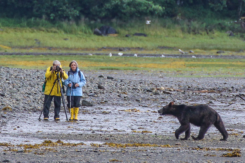
So we put our food away. Leah called Nancy, the other ranger, to ask if the paths were clear. Our path was at the upper end of an extensive mud flat at the mouth of Pack Creek. We could see a grizzly far away, clamming at the end of the mud flat near the water (we later learned he is called "Junior") and several more at the other side of the estuary. About 5 minutes after we started walking, Junior stood up and started running. That's exciting! However, he was running toward us! He was a ways away but we were clearly in his path. What did the ranger say? "Stop and let the bear decide." Ok. Easy in theory. Urs picked up his camera (of course!!). Junior stopped. I blew my whistle quietly to make sure he knew we were there. He started toward us again. And after another whistle, Junior changed course and went into the woods. Nancy was there in less than a minute for a debriefing.

Junior is a 2.5-year old subadullt (read "teenager").  An adult male grizzly may have spooked him; adult males are known to eat the young bears.  Later, we saw Junior with his friend Cino (as in Cappuccino, the daughter of Mocha!)  They became acquainted when they were cubs.  Cino is a year older and has been on her own for a year.  This is Junior's first year on his own.  They nuzzled noses and frolicked.  Then began foraging together.

Mocha and Cocoa
One way of telling a male from a female is by the direction of their urination. The trajectory of a female's urine is horizontal behind her rump. The male's is down between his legs. Nancy eventually set up her spotting scope on a urinating female so we could see!
Cocoa Cuddling Mocha
Mocha is a 17-year old mother with a half-year-old cub that I called Cocoa. Mocha fished in the creek several times. By the end of the day, they were in the part of the creek closest to us. Cocoa snuggled up to her mother every time Mocha sat down for a rest.
Junior
Junior
Nancy and Junior
A group of photographers with big lenses arrived. Junior caught some fish and then wandered up to our viewing area. Nancy thought he might have come even closer if the photographer had stayed still. You will see in the pictures that he was quite close.

Stan Price and his wife had a homestead in Pack Creek from the mid 1950's until the late 1980's. They raised several orphaned bear cubs, who stayed in the area and returned later with their own cubs. This was the start of the habituation of the bears to people. However, the strict rules regarding food prevents the bears from associating people with food. A total of 95 square miles on Admiralty Island is protected habitat for grizzly bears.

Grizzly cubs are with their mothers for 2 to 3 years. Subadult siblings may stay together for an additional couple of years. They mate at about 7 or 8. Females may live to be 30 years old; males live to 20.
Nancy told us lots of stories and answered a string of questions. She had an encounter with mom and cub, where the mom lay down for a snooze near the viewing area and the cub was curious about Nancy. Nancy glared back at the cub but he didn't move. Finally, mom got between Nancy and the cub. She thinks that the mom had taught her cub that people were not dangerous in the viewing area, but had yet to teach him to keep his distance.

At the end of the day, we had seen about ten bears, had great conversations, had sun warm enough to take off all but the last layer, and enough rain to get the umbrella for Urs's camera wet. After 10.5 hours in the park, we were about to leave, when a mother with two cubs arrived. We watched another 5 minutes and left before it got dark. Very nice day.
Curiosity
Junior
Mocha and Cocoa with a Salmon


Sunday, August 5, 2012

Currents and Rain

Friday August 3 - Saturday August 4

We left Petersburg on Friday on a rising tide. The current had been against us on a rising tide when we were going south to Petersburg, so it must be with us going north, right? In the channel outside Petersburg, the current was about 4 knots against us (we only go about 6 knots)! And with a cold engine, we cannot go full speed. The current was rushing around the buoys and pushing them over. Oh, no. What's happening. However, when we got into Fredrick Sound, the current changed northward, 2 knots with us; thank goodness. It was pouring rain.

In the evening, Urs listened to the weather forecast. Rain likely Sat; rain likely Sun; ... rain likely Wed. We both shook our heads and said we were sick enough of rain that maybe we should throw in the towel and head south.

Saturday morning, the sun was breaking through the clouds. A moose grazed in the grass behind the beach -- the first we'd seen in this environment! So maybe we didn't need to turn south! The first 4 hours of motoring were in thick fog with 1/4-mile visibility. Fortunately the logs were rare, but we did see several large bergy bits!

Sun finally came out and it got so warm that my socks came off and slacks got rolled up! The temperature was only 60 f / 16 C but the sun made all the difference

We'll head toward Pack Creek, the well-know bear-viewing sanctuary tomorrow; our permit is for Monday.

Thursday, August 2, 2012

Petersburg

Tuesday July 31 to Thursday August 2
Preparing to Tie up to Dock in Petersburg in Pouring Rain
Petersburg has a proud Norwegian heritage.  Nearby LeConte Glacier was the source of ice for the fish cannery built in 1897 by the Norwegian Peter Buschmann.  Many Norwegians came to work in the cannery and there are lots of blue-eyed blonds on the streets.

Today, the importance of fisheries is evident miles before reaching the harbor, as packers pass by fully loaded toward Petersburg.  Then as the harbor comes into view, we also see swarms of Arctic terns and sea gulls feeding on fish waste.  Closer, we notice the smell of fish and the noise of the machines.  There are 3 large harbors filled with large and small fishing boats.

We moored next to a fishing boat run by a gentle, young family with two girls about 8 and 10 years old.  They had been out fishing and came into port just to reprovision.  In the morning, they left at 4 AM.
Raven Song in Middle of North Harbor, Petersburg
Packer in North Harbor
Seiner Tidying Nets
Fish Processing Plant
Sing Lee Alley
Wednesday was a sunny warm day. We walked all over town and talked to lots of very friendly people. All of the buildings on the waterfront are on stilts, as the water comes way in at high tide. Walked on the boardwalk along a slough; houses lined each side. At low tide, people can walk across the mud to visit their neighbors. By 8 PM, we were hungry but all the restaurants were closed. One woman told us to try the pizza parlor; even it wasn’t taking any more orders.


Sons of Norway Hall
Memorial to Fishermen overlooking Slough
Hammer Slough
Hammer Slough

Speedy Trip to Petersburg

Sunday July 29 – Tuesday July 31

Bow Lookout in Drizzle
I discovered that I had miscalculated the number of bottles of eye drops that I needed.  This was a particular problem, because there are not many pharmacies in the wilderness.  We discussed the options.  1)  Cut out some of the anchorages we wanted to visit and travel long days to reach Petersburg a day or two after the end of my prescription. Or 2) ask friends to mail the prescription from Vancouver to General Delivery somewhere; however, a package I mailed from the main post office in Sitka took 3 weeks to arrive in Vancouver and who knew what customs would do.  So we got to Petersburg after 3 hard days of motoring. 
Two Humpbacks
Our route went up Chatham Sound and east in Fredrick Sound.  It was amazing to listen to the weather forecast:  no matter what was predicted, no matter which direction we went, the wind was always on our nose!  We slowed down sometimes to watch feeding humpbacks; one group was particularly active.  Chatham Sound is apparently one of their favorite summer feeding spots.  We learned that humpbacks have to feed a lot in summer, as they do not eat during the winter.
Wind of 36 Knots (Apparent Wind 42.8- Boat Speed 6)
Tuesday weather was particularly confusing.  Monday evening, the prediction was for west winds 10 knots.  Great, some motor sailing!  However, when we got out into the sound, winds were up to 36 knots from the south – where we were heading.  That was gale-force winds.  Furthermore, the weather forecast said nothing about a gale warning.  And nearby weather stations north and south of us were reporting 10-knot winds!!  Anyway, the waves were not steep, more like a chop, and Raven Song just plowed through it all.
Storm Clouds
Rain on the Windshield

Sunday, July 29, 2012

Southern Portion of West Coast of Baranof Island

Wednesday July 25 - Saturday July 28

Pyramid-shaped Mountain is behind Sitka, Baranof Island
We left Sitka and headed down the outside coast of Baranof Island. We had a wonderful weather window: calm seas and light wind (usually on the nose; Urs would have liked more wind from a better angle). Calm seas was important as some stretches would be in the open waters of the Gulf of Alaska. For the first day and a half, we found protection cruising behind a maze of islets and rocks.
Sevenfathom Bay

Our first anchorage was Sevenfathom Cove. It was surrounded by a fairy-tale forest and high mountain peaks with snow patches. We particularly liked the quietness after 6 days in Sitka. We saw an unusual sight: a juvenile bald eagle on a tree with its wings spread out perhaps to dry like cormorants; maybe he had been fishing. Higher up on another tree a raven was sitting and calling loudly.
Entrance to Scow Bay

On Thursday, we had a lunch stop in Scow Cove; the entrance was particularly narrow. Then out to open seas for the first time since leaving Sitka. The seas were as good as you could imagine, hardly any swell. The scenery is very interesting and typical of an outer coast. Because of the heavy, continual pounding of surf during storms, nothing has a chance to grow on the rocks; they are bare up to about 150 feet. We anchored in Still Harbor, another beautiful anchorage surrounded by dense forest. The evening's excitement was a loon, flying with partially folded wings to descend rapidly from high above to the water; then she took off with a fish dangling from her beak.
Foggy Morning in Still Harbor

Pea Soup Fog -- There really is land out there;
see instruments below

Friday, started out pea-soup fog and drizzle; we turned on the radar. We had less than half a mile visibility. The radar showed several nearby boats but we could not see them until the fog lifted. On the outside coast, we had to weave our way through a fleet of trolling fishing boats. Packer boats often anchor in nearby harbors, buying fish from the fishermen and then taking the fish to a processing plant, while the fishing boats keep on catching fish.
The Chart Plotter on the Left Shows our Route along the Shore, the Arrow is our Boat;
The Radar on the Right Shows Land About 1.5 Nautical Miles Away

Sun Shining in Puffin Cove
Rainbow at Puffin Cove

We headed up Puffin Inlet and then made a 150-degree turn toward our intended anchorage. The passage appeared so narrow. I said: "We are not going into there, are we???!!" When Urs said, "Yes", I headed to the bow. Puffin Cove turned out to be a lovely spot, big enough for one or two boats. It is surrounded by very steep, high mountains with deep green slopes and snow patches. Eventually the sun came out and a spectacular rainbow appeared. A huge school of herring attracted wildlife. They were jumping in the air on all sides of us. A lone female sea lion spent several hours gorging herself on the fish. Then about 6 bald eagles swooped in to scoop up fish until nightfall.


Bow Digging into Wave
Saturday morning, swells were coming into Puffin Inlet. Outside, the water was very confused: swell from the west and wind-waves from the south. It was an uncomfortable chop; Raven Song dug her bow into a number of the increasingly large swells. We plowed on slowly. Then, we saw lots of birds (puffins, murres, phalaropes, skuas) and realized that the water had suddenly become flat. We don't know what caused the difference -- changing tide? currents? And another question: Apparently male phalaropes incubate the eggs and raise the young; what are the females doing? Do they head south or wait to migrate with the others?
Common Murres

Before rounding Cape Ommaney (he was the provisioner or "victualler" for Capt Cook), we avoided the lines of several commercial fishing boats. We watched some sports fishermen in an anchored skiff; Urs said they were probably fishing for halibut. Later, after we had docked in Port Alexander, a guy stopped and offered us three large pieces of halibut -- he was the skipper of the skiff that had been halibut fishing -- they had been watching us, too! and thought it only appropriate to share their catch. We gave him a Swiss chocolate bar in trade, which he gladly accepted.
Small Troller
Cape Ommaney at Southern Tip of Baranof Island
Cape Ommaney

Coming Into Port Alexander
Entrance to Port Alexander on the Right at Low Water
Problems Anyone?  Or Maybe a Hamburger with the Works?
Fisher Depositing Two Salmon with Float for Us
We walked along Port Alexander's extensive boardwalk. Population is about 40 but many sports fishermen have summer cabins. There is a school; one boy asked if we were the new teachers. Alaska will fund a school if there are at least 10 students; Port Alexander has 14 and the new teacher will be bringing her own 5 -- good news for the school. Of course, we had to visit Laughing Raven Lodge and Problem Corner Cafe, a tiny place that sells an amazing variety of food. There is a cute general store. Then we walked along the beach collecting flowers and rocks. Quite an interesting and quaint place. The people are very friendly. We really enjoyed our stay. Port Alexander was named after Alexander Baranov, the first governor of Russian America.

As I was putting dinner on the table, a small boat, the F/V Anna Louise, was trying to raft up to the boat in front of us. The skipper's dog fell into the water. While he was busy retrieving the dog, his boat floated back with the current bending one of our stanchions. Urs was able to bend it back. He apologized and said he had no money to pay for the damage, but he promised us some fish if we called him on the radio early in the morning.

And as promised, the skipper of F/V Anna Louise responded to Urs's radio call. He was not far away and had some fish. He put two fish into a plastic bag, tied the bag to a bit of floating line with a float. Then, he put it all into the water while trolling past us with all his fishing gear in the water. We retrieved the fish, put a Swiss chocolate bar into a new bag for him. Then he swung around and retrieved his float and the chocolate. He really appreciated it and apologized again for the incident. Salmon for dinner and left-over halibut for lunch!
Laughing Raven Lodge
Float Tree!
Common Harebells
Fishing Boats Unloading onto a Packer