Tuesday, July 24, 2012

Outside of Chichagof – Part 4

Wednesday July 18
<><><> 
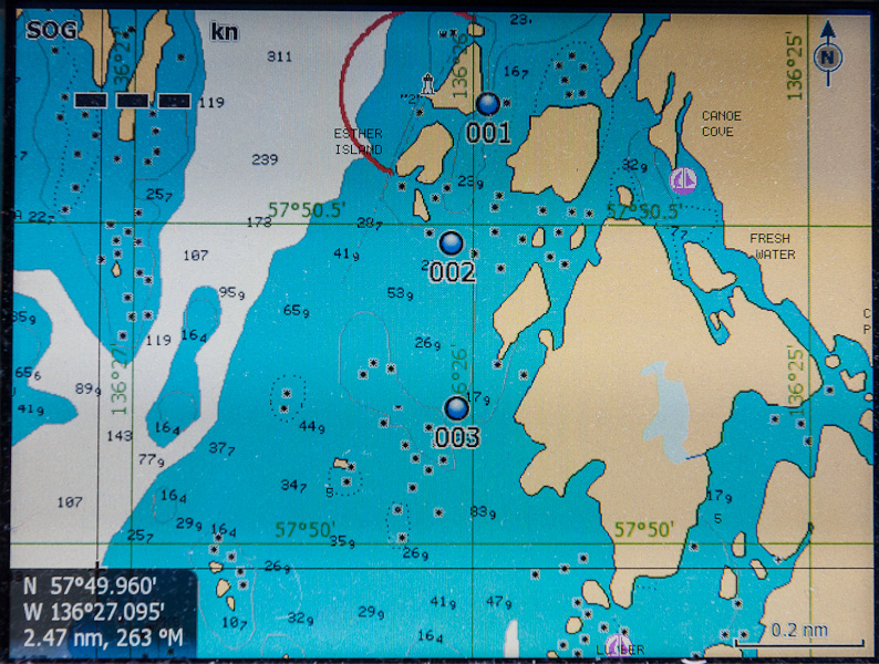
Piehle Passage with Blue Circles Marking the Waypoints
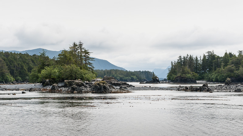
We got up early to go through a narrow, rocky passage at low water in order to see more of the rocks. Then we cruised in open waters of the Gulf of Alaska until we reached Kalinin Bay on Kruzof Island.

What Bears are Supposed to do when they see Humans
We had heard there was a hike to Sea Lion Beach on the outer side of the island.  We stopped by Northern Wanderer, the boat that had been in the same anchorage and whom we had followed through the rocky passage.  Larry told us to expect to see bears and we said we did.  We left at 3, not knowing how long the hike would be.  There were only boot prints in the mud at the beginning of the trail; that was reassuring.  However, within 10 meters, we saw relatively fresh bear scat and then more and then more.   We walked along an estuary and saw about 7 bears on the other side; they bolted into the forest as soon as they saw us.

Lake on Sea Lion Cove Walk
Then the trail went through a mature Sitka spruce forest.  We talked loudly and blew our whistles to prevent any bears from being surprised by our appearance.  The trail went up a pass and became a boardwalk over a bog – more scat on the boardwalk but no prints in the mud.  Urs stopped to take lots of pictures; I observed the flowers.  Then we came to a lake with lots of deer prints in the sand.  We’d been walking about an hour and both started to wonder how much farther it was to Sea Lion Cove. Another 45 minutes and we finally reached the outer coast.  It was a beautiful, wild, sandy beach with breaking waves.  The sun was out and so were the black flies.  We sat down for some water and crackers and then turned back.
[More after pictures.]
Boardwalk through the Bog
Water Lily
Water Lily Pond
Sea Lion Cove
E
Alaska Violet
White Bog Orchid
Back at the estuary we saw 7 grizzly bears, which immediately ran away. Shortly before we reached our dinghy, we saw two bears, between us and the dinghy. These two were apparently 2- or 3-year olds. They did not run away. Urs took some pictures. They still kept on feeding on the grass. We talked loudly and whistled. They still didn’t leave. We heard Larry blow his boat’s horn, either to warn us or to scare the bears. They still didn’t go. We saw Larry and Bill from another boat coming toward us in their dinghy. Bill blew his air horn. The bears only looked curious. Finally, Larry fired his rifle. Then the bears ran into the forest. When we walked along the trail, we could hear them huffing and could see them – that was the scary part.

We finally got back to the boat much later than we had planned. We were tired and covered in bug bites.
No Evidence of Human Remains in Scat
Bears Calmly Grazing between Us and Our Dinghy
Was that an air horn?!! - Raven Song in the Background


The Chart is wrong!!! Outside Chichagof -- Part 3

Tuesday 17 July (written by Urs)

We waited until high-water slack before leaving Lake Anna.  Judy was uneasy about going back into the Gulf of Alaska because we had not been able to receive weather forecasts and because the wind was relatively strong.  But it was no problem. We first wanted to go to Waterfall Cove, a beautiful anchorage with a spectacular waterfall and nice bear-friendly grassy flats. However, we found it very tight and the wind was blowing strongly into the anchorage. What really scared us off was also the fact that the chart did not seem correct. The GPS showed us very close to land when we knew we were in the middle of the space between the two sides and chart depths didn’t match what our instruments read. We were already well anchored when we decided to abandon the spot, and go on to nearby Falcon Arm, a side bay to Slocum Arm and behind the Khaz Peninsula.

Black arrow shows where we are on the chart.
Cross in middle of bay is where we were
For Falcon Arm, our guidebook talked about a rock in the middle of the outer bay being shown incorrectly on some older charts. This was corrected in all three of our charts, one paper and two digital. They should be correct since they have only recently been downloaded from NOAA, the US marine chart authority!

At center left is the rock which was 350 meters away
However, when we were deeper into the bay and close to the tip of a peninsula, the GPS showed us still quite a ways off. Something was clearly wrong here too but the discrepancy was larger. We proceeded cautiously into the inner bay by sight and depth sounder and bow watch, ignoring the GPS position shown on both of the two independent plotters. Visually, we were anchored in the middle of the bay; however, the GPS digital charts had us sitting on top of a rock at the entrance to the bay, some 385 yards away (350 meters)!!! This is an example of the chart being clearly wrong relative to the GPS position. I also checked the chart to see what horizontal chart datum (a base line position reference for charts) had been used. The chart says they used NAD83, which is practically equivalent to WGS84. Our GPSs are set to WGS84, hence, we are talking the same language, and the chart and GPS should be in synch. I conclude that the chart is just clearly wrong!!!

We have learned a long time ago that one must always be alert and consider all the inputs. The following text is printed on the chart in red: "The prudent mariner will not rely solely on any single aid to navigation ...."

So much for the excitement of the day.

Outside Chichagof Island Part 2

Sunday July 15 – Monday July 16

July 15
Elbow  Passage to Klag Bay
We anchored at Klag Harbor after a very intricate passage with many narrow and zig-zag channels. We explored the gold and silver mine site that closed in 1943.  From 1905 to 1943, $13,000,000 worth of minerals was extracted from the mine.  Urs took many pictures of old rusty equipment and collapsed houses. I collected stuff: rusty nails, some kind of pottery used presumably for some technical purpose, and foxglove.  The gold mine was like an outdoor museum of rusted electrical and mechanical equipment:  frayed cable on a winch; a motor that Urs identified as electric; rock crushers and separators; umpteen similar metal boxes that might have housed switches or dynamite or …  And then there was daily life:  a series of tiny collapsed cabins with some paint still on the walls and electrical wiring; shards from dishes; lots of nicely embossed radiators for heating the cabins; glass jars with unidentifiable, no-longer-edible contents.  I wondered where they ate and washed.  A tin hardhat or cooking pot was in the intertidal waters.
 No bears but the salmon are gathering and jumping.
Historical Photograph of Chichagof Village and Gold Mine
Chicagof Village Today

Pretty Rusty!
Dinghy Safely on High Ground
Rusting Heating Radiator
Sea Otter
Rusting Cable
Foxglove
Old Boiler
Ground Cone (Grizzlies Gorge on this)
Shovel
Red Necked Loon
Rusted Electric Motor

July 16


Lake Anna
Near Klag Harbor is Lake Anna, where we anchored at a river mouth.  This is not really a lake, but it is a fairly isolated body of water with a narrow entrance and strong eddies and currents.  Sister Lake is a large lagoon that empties into Lake Anna with a 12-knot current on the ebb tide.
Urs worked all morning to fix the heater. The heater is important in this 10 C (52 F) weather. It seems to work again fine now. Time will tell. Heavy drizzle. We took the dinghy for an exploring ride.


Outside of Chichagof Island Part 1

Thursday July 12 - Saturday July 14, 2012
Surf in Lisianski Strait
Thursday was a beautiful sunny day.  We got up and checked the weather, tides and charts to see if the outside of Chichagof was doable.  Decided to scrap the internet cafe in Pelican and head out instead, in spite of the predicted 9 foot swells on the outside and an approaching weather front.  We went out Lisianski Strait but used a passage behind rocks and reefs for protection from the swells.  This is the area where Bering’s sister ship lost its two skiffs to the waves and rocks in 1741.  This was one of the areas where there were so many rocks that Urs told me to take the photos!  We went into the first available anchorage, Ilin Bay, just around the corner.  This is an intricate and well protected anchorage, surrounded by virgin forest and high mountains. We could hear the outside surf and see some white water hitting the rocks, through a narrow passage.
Sea Weed around Rocks in Lisianski Strait
Rocky Entrance to
Note:  Bell in lower left means shallow depth
Lisianski Passage -- Blue Dots are Waypoints between Rocks
 Friday, we headed from Ilin Bay out into fully open water. We motor-sailed in the Gulf of Alaska! The swell was not too bad. Nevertheless, I felt a bit queasy and Magpie was close to tossing her cat treats. The outside portion was only about an hour and then we headed behind rock and reefs again.

 <> 
Ilin Bay
Gulf of Alaska


Baker Cove
 We anchored in Baker Cove, a beautiful enclosed cove with great bear meadows and untouched wilderness forest surrounding us. High peaks in the distance. The sun came out and we took the dinghy through the surrounding waters. We saw nine different grizzlies today. Quite amazing! Two mothers with two cubs each and three different males. Urs photographed them all – of course! Within our bay there was a male bear and not too far away a mother with two cubs; mom was wary, always on watch and keeping her distance. The male was about the same size as the mother and kept his distance too. In the other bay, we saw a fairly large male. He left as soon as he noticed us. The bears here are very skittish.
Grizzly Bear

Tuesday, July 17, 2012

Elfin Cove and Pelican

Wednesday July 11
Elfin Cove Inner Harbor
We went to Elfin Cove and were lucky to find moorage, as there is limited space for transients. Elfin Cove has a continuous boardwalk along the shore to the cozy inner harbor, which is devoted to sport and commercial fishing boats. Small homes and guest cabins lined the boardwalk on the land side. We admired the small gardens; one had a mass of columbine and blue poppies! Some of the houses were falling apart but it seemed that some people are getting into tourism. In 2009, the population of Elfin Cove was 25 year-round residents; however, with all the fisherfolk, it felt like there were 500 people there. Signs and flower pots decorated the houses. My favorite was labeled "Red Neck Chimes"; it was 6 Budweiser cans of different sized supported on a wire.  We followed the signs that pointed to a bright yellow house, where we bought smoked king [Chinook] salmon.
Outside a Sports Fishermen's Cabin
Orca Yin and Yang
SECONDPICTURE
Boardwalk away from Inner Harbor
Blue Poppies
Porch Decoration
Houses on Stilts to Accomodate High Tide
Elfin Cove Inner Harbor -- Yellow House Sells Smoked Salmon
This Year's Sports Fishermen and Their Catch
Garden Whimsey
When we got back to the boat, the dock was filled with commercial fish boats, some rafted up. There was a salmon opening and they were heading out. Elfin Cove was originally called "Gunk Hole". However, the first post mistress wanted a better name for her home; her husband's boat was called Elfin.
Sports Fisherman with their Catch
We decided to head on to Pelican, another boardwalk community. It was named after a fish packing boat. The docks were new and very solid, so it was surprising to see how rundown the town is. The cold storage facility for fish closed in 2004. The rows of bunk houses that may have housed workers looked pretty dilapidated. There was a liquor store but the grocery store has been closed for a number of years. Groceries have to be flown in from Juneau for a fee of $50. We photographed a group of sports fishermen celebrating their halibut catch with beer. One of the halibut was longer than me and about 160 pounds; I hate to see the larger halibut caught, as they are females and their habitat is different from the smaller males.
"Hippies Enter on Right" -- there is no entry on the right!
Bunk House and Cold Storage
Sign on Library
Practicing the Emergency Evacuation
Boardwalk in Pelican

Raven
We moored behind a boat from Victoria and, of course, had to talk. Vivian is a physician, working as a locum for years. She single-handed all the way from Victoria, sometimes doing 14-hour days without an autopilot! Amazing. She had just done the outside of Chichagof Island, as we had wanted to do before Glacier Bay. Rose's Pub is an infamous place, so we went together with Vivian for dinner. Food was good; atmosphere was smoky and very calm. We have heard first-hand stories of the antics at the bar. Rose had the habit of suddenly pulling her blouse wide open unexpectedly in front of customers and one of our friends had her own blouse pulled open.